

North Carolina-Land Surveyors’s Package: 15 PDH
Original price was: $90.00.$60.00Current price is: $60.00.
North Carolina–Standards of Practice for Land Surveying: 1 PDH
In this course the student will review and examine the standards of practice for land surveying in North Carolina and satisfy the one hour of continuing education required by the 21 NCAC 56.1703.
Land Surveyor’s Ethics: 2 PDH
In this ethics course the student will understand the standards of professional behavior for adherence to the highest ethical conduct and revisit the emphasis that the holder of a professional license has a direct and vital impact on the safety, health, and welfare of the public.
Introduction to Small Unmanned Aircraft Systems (sUAS) for Land Surveyors : 4 PDH
This course is an introduction of using sUAS in land surveying. From FAA licensing requirements to common sUAS products and software, with an understanding of these basics a land surveyor can easily get started in using this up and coming technology.
Airborne Topographic LiDAR: 3 PDH
In this course the student will review the principles of Airborne Topographic LiDAR and learn how to utilize methods to employ this technology in the field.
Construction Surveying Curves: 3 PDH
In this course the student will learns to locate points using angles and distances for establishing curves. An essential tool in construction surveying when determining the line of a curve for road layout or some other type of curved construction.
Corner Restoration Fundamentals: 2 PDH
This course provides guidance for documenting accurate boundary descriptions and locations by survey in the standards followed for Executive and public land orders and proclamations.
Preview Course: North Carolina–Standards of Practice for Land Surveying
Preview Course: Land Surveyor’s Ethics
Preview Course: Introduction to Small Unmanned Aircraft Systems (sUAS) for Land Surveyors
Preview Course: Airborne Topographic LiDAR
Preview Course: Construction Surveying Curves
Preview Course: Corner Restoration Fundamentals
Related Courses
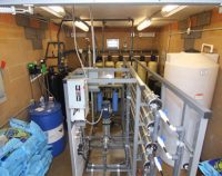
Design of Small Water Systems: 3 PDH
$18.00 Add to cartThis course focuses on criteria for water source development, design of small water supply, treatment, and distribution systems. This professional engineer online course is from the U.S. Army Corps of Engineers manual on the Design of Small Water Systems. This manual provides information of interest to planners and designers of small water systems. The major emphasis of this course is on the design of systems that will be effective and reliable, requiring a level of operation and management activity commensurate with their physical size and the available sources.Instructor: Raymond Bosek, PEThis course focuses on criteria for water source development, design of small water supply, treatment, and distribution systems. This professional engineer online course is from the U.S. Army Corps of Engineers manual on the Design of Small Water Systems. This manual provides information of interest to planners and designers of small water systems. The major emphasis of this course is on the design of systems that will be effective and reliable, requiring a level of operation and management activity commensurate with their physical size and the available sources.
SPECIFIC KNOWLEDGE OR SKILL OBTAINED
This course teaches the following specific knowledge and skills:
- Preliminary Water System Planning and Design Considerations
- Water Quality Requirements (State, EPA, local)
- Water Quantity Requirements
- Water Source Options and Source Development
- Water Treatment Unit Operations such as Disinfection, Iron Removal
- Manganese Removal, Hardness Removal, Taste and Odor Removal
- Stability and Corrosion Control, Turbidity Removal, Color Removal, and many other technologies and their applications
CERTIFICATE OF COMPLETION
You will be able to immediately print a certificate of completion after passing a 20 question multiple-choice quiz. The quiz can be retaken unlimited times until a passing grade of 70% or better is earned. This course satisfies 3 professional development hours (PDH) of continuing education.
Preview CourseClick “Preview Course” to View Prior to PurchaseClick “Add to Cart” to Purchase and Access Quiz
Roller Compacted Concrete Pavements: 1 PDH (On-Demand Webinar)
$10.00 Add to cartThis introductory course provides the engineer the basic understanding of the fundamentals of RCCP in design and construction. It presents an overview of the best practices for roller-compacted concrete pavement, its uses, its mixtures and construction.Instructor: Raymond Bosek, PEThis introductory course provides the engineer the basic understanding of the fundamentals of RCCP in design and construction. It presents an overview of the best practices for roller-compacted concrete pavement, its uses, its mixtures and construction.SPECIFIC KNOWLEDGE OR SKILL OBTAINED
This course teaches the following specific knowledge and skills:
- Understand materials used for RCC pavements
- Explain Construction and Design of RCCP
- Describe Paving Operations of RCCP
- Discuss Jointing and Texturing of RCCP
CERTIFICATE OF COMPLETION
You will be able to immediately print a certificate of completion after passing a five (5) question multiple-choice quiz. The quiz can be retaken unlimited times until a passing grade of 70% or better is earned. Records also are available anytime online by accessing your account on EZ-pdh.com. This course satisfies 1 professional development hours (PDH) of continuing education.
Our On-demand Webinars are recorded from live webinars conducted utilizing GotoWebinar.com service (chosen for reliability, ease of use, no software required and ability to attend using your computer, tablet, or smart phone).Upon purchase your will have access to launch the On-demand Webinar.
The On-demand Webinar will play through similar to a live webinar, however you will have the ability to take anytime, pause/rewind and complete in more than one session.
Upon completion you will then answer a short five question quiz, which can be taken unlimited times until passing, immediately generating a certificate of completion.
You may print or save your certificate or access anytime within your account.

